

Related Posts:
> See the "lifestyle choices" category of this blog
> Built-in exercise is a major benefit of cycling for transport
Details:
1. Popular "most liveable city" rankings are useless in choosing where to live
- There are three, popular annual indexes - The Economist, Mercer and Monocle - which rank cities according to factors like: "medical care, safety/crime, political stability, climate/sunshine, public transportation, education, access to nature, urban design and business conditions. See: Wikipedia - World's most livable cities
- However, all of these rankings are flawed for different reasons. The three above rankings tend to be used to determine where executives relocating for work would be best off rather than measuring quality of life for the average city resident. The biggest issue is simply that the disparity in lifestyle, quality of life and opportunities can be huge based on where in a city you live and your personal circumstances.
- For example, Melbourne has ranked first from 2011-2013 on the Economist's criteria but this is routinely criticised as applying only to nicer suburbs (mostly inner city) and not taking into account affordability, urban sprawl, public transport gaps and the many suburbs with less amenities. See: > Welcome to the world's most livable delusion; > Is Melbourne really the World’s Most Livable City?; > Hauling in the sprawl
2. Cycling city rankings like the Copenhagenize Index are also not a useful guide in choosing where to live
- Copenhagenize produces a bicycle-friendly index of cities according to criteria including: advocacy, bicycle culture, bicycle facilities and infrastructure, bike share, gender split, modal share, perceptions of safety, social acceptance, urban planning and traffic calming. See: Copenhagenize Index 2013 - Bicycle-Friendly Cities
- While the index does a decent job of grading a city's urban design and transport planners at the macro level, it isn't very useful for individuals. There is much more difference in the bicycle-friendliness between Fitzroy North in inner-city Melbourne and an outer Melbourne suburb than between Melbourne and any city on its list. The implication is that in most cities there is great value and opportunity in conscientiously choosing a suburb to live based on how easy it is to walk or cycle for your common trips.
3. Cycling rates are irrelevant on their own; walking and cycling must be considered together by individuals
- In terms of affordability, convenience, simplicity, reliability, safety, health and enjoyment, walking trumps all other means of getting around including cycling. The only disadvantages it has are the limitations on distance and that it's not as fast. However, for distances under 3km, walking is often the best way to get around, especially for local trips near where you live or study/work.
- Hence, cycling rates shouldn't be considered as the sole critical measure, instead active transportation (primarily walking + cycling) is what should be counted. In determining where to live, work/study and other activities or destinations you should be considering the potential ease of walking as well as cycling. Living in a location where you will walk for 70% of your trips and cycle for none is better than living in a location where you will cycle for 30% of your trips and walk for only 10%.
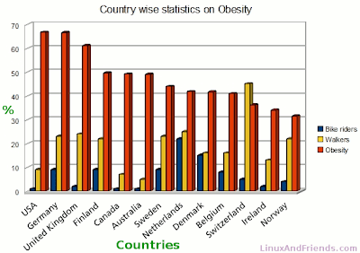
- In the below graph you can see that Switzerland has a combined walking plus cycling rate of around 50% while Belgium's is less than 25%. Yet Belgium has a higher cycling rate. I'd argue that the combined "active transportation" rate is far more important to quality of life, health and happiness than the cycling rate.
4. The benefits of active transportation to individuals and families
- Active transportation is any physical activity undertaken as a means of transport. This generally means walking or cycling but could also involve foot scooters, rollerblades and skateboards. The common element being that you incorporate physical activity in your means of getting around, including as part of your use of public transport.
- Getting around on your own power can certainly be cheaper, easier, safer and more enjoyable than the alternatives, especially using a car. In addition, active transportation has particular benefits involving health, lifestyle and your local community.
The Co-benefits of Physical Activity (be active W.A.)
5. Locations that are designed for active transportation have more accessible facilities, pleasant spaces, stronger communities and facilitate healthier lifestyles
- "What is truly valuable is the ability to easily access the facilities and services of a city, ideally by making them walkable—bringing people, activities and places in easy reach of each other. A neighbourhood’s walkability is not only convenient, but also makes for a desirable lifestyle." See: The value of closeness
- The Walkable and Livable Communities Institute visually summarises the difference between streets and places that facilitate active transportation and those that discourage it in its "Photo Visions" section. Obviously these are ideal scenarios, but it is extremely helpful in isolating the differentiating factors you should actively use to inform decisions on where to live.

- Of course, individuals and families shouldn't wait for such radical transformations to take place before enjoying the benefits; they'll be dead first. Instead, they should carefully choose where to live now with the potential for walking and cycling for their common trips as a key criteria.
6. Walkability varies massively within cities
- In choosing where to live, you should have walkability and bikeability (for you and your family's common trips) as top priorities. Walkability is most important, as it implies your immediate surroundings can enhance your health, lifestyle and local community.
- The obvious problem is that compromises have to be made. The most walkable suburbs are generally the most expensive to buy or rent in. Nevertheless, people who value quality of life can make compromises on how big a house they need, renting instead of buying (at least at the most suitable life stages) and adjusting their lifestyle to suit walking and cycling (and, if possible, being car-free).
- A very useful tool to scan walkability and identify suitable homes before evaluating locations in person is Walk Score. The massive variation in walkability scores in Melbourne is a useful illustration of how inaccurate and useless city-wide ratings of livability, walkability and bikeability are. See: Walk Score - All Melbourne Suburbs Ranked
- Tarneit is a rural-urban fringe suburb of Melbourne, 25 km west of Melbourne's central business district. It and the surrounding suburbs have some of the fastest growing populations in Australia because land is among the cheapest available in metropolitan Melbourne. Despite their high populations, these new suburbs have terrible urban design and a car is required for even the simplest local trip like going to the nearest shops. Tarneit's Walk Score of 18 reflects this accurately.

- Residents who move to Tarneit are driven by the affordability of large houses and blocks but are focused on the sticker price (buying or renting) alone and do not adequately consider the impact of this absolute car dependence on their health or quality of life. The articles below explain this trend in housing choices and the implications.
> Sick suburbs
> Population growth overwhelming transport
> Home buyers happy to take Tarneit for granted
> Fringe suburb Tarneit just keeps on booming
> Waiting for a bus that never comes, students walk the hard road
> Ninemsn Suburb Reviews - Tarneit
- Even a simple, local trip to the shops in Tarneit requires a car. It isn't feasible, safe, comfortable or pleasant to cycle or walk for almost any local trip.

- At the other end of the scale, suburbs like Fitzroy North have Walk Scores in the 90's. As the summary says: "daily errands do not require a car". As mentioned in my post - Map your common trips to see how to really make cycling feasible - "the nearest grocery shops, cafes, restaurants, bottle shop, post office and library are all less than 1km away" and so I walk to them.

- Walk Score provides a fantastic "My Commute" tool that helps calculate commute distances by foot, bike, public transport or car. You can use this in reverse to enter your current or prospective home address and set a time by foot or bike to see which types of trips are feasible. Below is the distance from my house Walk Score says a typical person can walk in 10 minutes. In this diamond I have marked some of the actual destinations my girlfriend and I routinely walk to. I haven't included the Primary School and many types of shops/services we don't currently use - which would also fit in this diamond. This is what high "walk scores", walkability and liveability mean in practice: regular destinations that are sufficiently close, safe and pleasant to walk to.

- For comparison, let's consider the walkable possibilities for the Tarneit street mentioned as being part of the first development in the area (see Home buyers happy to take Tarneit for granted). I used Walk Score to create these maps for 11 Watagan Street, Tarneit:
- Distances to useful locations don't seem feasible to be walked to for most residents. They are generally too far, too scattered and not on a route designed for walking. Amenities and services in such suburbs are centralised in large shopping centres; here the nearest is 1.8km away.

- The 10min walk zone around 11 Watagan Street is almost solely residential and thus has few useful destinations. The nearest major shopping centre (Wyndham Village) is a 25min walk away according to Walk Score; assuming you could walk there on a pleasant-enough route.

7. Walkability varies significantly between neighbouring suburbs and even within suburbs
- Usually the suburbs around the walkable core (central business district in Australian cities) have high walkability but there is plenty of variation and many gaps. For example, Brunswick West is adjacent to Brunswick which has a high walkability score of 84, yet its score is only 66. Thus, even though they are about the same distance from Melbourne CBD, people walk much less in Brunswick West than Brunswick.
- On the Walk Score heat map, the walkable fingers (in green) stretching out from the city centre are easy to see. They tend to be around high streets and public transport corridors. While these distinctions (how close are the shops, amenities, public transport) are obvious when considering where to live, people often just assume they will have a car and mentally discount longer distances as minimal extra time by car. But for those who have the potential to go car-free or benefit greatly from active transportation, they need to minimise these walking distances to their common destinations and public transport.

- Essendon West has a Walk Score of 43 while two of the neighbouring suburbs have much higher Walk Scores: Essendon (71) and Maribyrnong (70). Housing affordability is comparable enough across these suburbs for people to significantly improve the walkability around the home they choose by consciously prioritising it. If compromises are necessary due to cost, instead of compromising walkability by shifting location, try compromising another factor (space, car parking). Also remember you can: Spend $85-230/week more on housing if you get rid of your car

8. You can improve walkability without paying more for housing
- Obviously the most walkable suburbs tend to be among the most expensive but in car-centric cities, walkability is not a top priority for many residents who are wedded to their cars. So by prioritising it and using web apps like Walk Score, you can get more walkability for the same housing cost.
- For example there are hundreds of 2 bedroom places to rent in Melbourne for less than $350/week which have Walk Scores above 80. The ones outside the inner city are typically in small pockets (shaded green) adjacent to local high streets and usually train stations too.

- E.g. 151-153 Coleman Parade, Glen Waverley is in a great walkability pocket close to many regular, local destinations and right on a train lane. Hence, it has a Walk Score of 97 while the overall suburb score for Glen Waverley is only 59. Note how the suburb profile shows that 151-153 Coleman Parade is right near the only major eating and drinking hub in Glen Waverley.

- Conversely, there are dozens of 2 bedroom places to rent in Melbourne for more than $500/week which have Walk Scores below 70. These are usually in residential pockets between train lines and high streets and thus have lower walkability. The suburbs are still desirable, pleasant and even easy to walk around, but the distances to clusters of amenities and destinations are too high:

- E.g. 29 Sackville Street, Kew is in a very desirable suburb which has an overall Walk Score of 71, but this house is just a bit too far from common destinations for walking to be a simple, quick alternative. Thus, its Walk Score of 43. Kew is also a suburb where most residents own cars and often drive so the lack of walkability in this pocket doesn't mean a proportionate reduction in price is likely.

9. Liveability and walkability is ultimately about action not just location
- A high walkability score for the area you live in or choose to move to simply means you have the potential to walk for many of your common, local trips. A high bikeability score simply means you have the potential to cycle safely and conveniently to common destinations. But if you don't take the other steps necessary to realise this potential you will miss out on the benefits of active transportation.
- Indeed, in car-centric cities like Melbourne, many residents live in suburbs with very high walkability and bikeability potential but choose to drive instead. They may still enjoy the amenities of these places but at much greater cost and with more time wasted in traffic and the inconvenience of parking.
- See the other guidance on this blog and also the Further Info links below on how to maximise the advantages of active transportation and build it into your daily life.
10. Consider together Walk Score, Bike Score, Transit Score and any other liveability data in choosing where to live
- Ideally you should consider together the ease of walking, cycling and using public transport in the place you live as you'll most often need a combination of non-car modes to maximise quality of life. Walk Score is developing data for all three but Bike Scores and Transit Scores are typically only available in North America currently.
- However, a look at the full set of Walk Score data available for a U.S. city and suburb is very useful as there are many other helpful aids. Below are some screenshots from the San Francisco city profile:

Further Info:
Sick suburbs
Partnership for active transportation
Healthy Places and Spaces - Active transport
Australian Dept. of Infrastructure - Active Travel
Australian Dept. of Infrastructure - Urban Policy
Why use active transportation? (Be Active WA)
BetterCitiesNow
Walkable and Livable Communities Institute
The value of closeness
Walk Score
Walk Score Blog
Walkability Checklist
Victoria Walks
South Australian Active Living Coalition
> Streets for People - Compendium of South Australian Practice (pdf)
Melbourne: most livable and best connected? - The economic benefits of investing in public transport
The list: Melbourne suburbs' liveability ranking revealed
- Useful reference but I don't agree with the rankings as many criteria don't make sense. E.g. Hilly suburbs ranked higher; car travel considered but cycling and walking mostly ignored.
What Happens When a Town Puts People Before Cars?
Why medium density housing is a health issue
Urban Sprawl: Your city's urban fringe (Skyscrapercity.com forums)
Grist: Hey, list-makers: Most millennials don’t want to live in sprawling, car-dependent cities
The Urbanist: Transport disadvantage in the suburbs
The Atlantic: Do We Look Fat in These Suburbs?


